by
Kirstin Davis - City of Spokane
| Jan 10, 2023

Maintaining 2,200 lane miles of streets is more complicated and costly than one thinks, especially when those streets are located 47.8 degrees north of the equator where freezing and thawing cycles are an annual event. The City of Spokane developed the Six Year Comprehensive Street Program in order to take the best care of streets and maximize their lifespan by coordinating assessment, planning and resources and be in alignment with the transportation goals and polices of the City's Comprehensive Plan. The City of Spokane uses an asset management approach for maintaining the streets. This allows the City to program the correct maintenance utilizing different tools to complete the maintenance. To determine the correct tool to use current pavement condition information is necessary.
Did you know streets are rated on a scale from 0 to 100 using a "pavement condition index" (PCI). New streets begin at a PCI of 100 and gradually deteriorate over time. Often times "fair" streets can become "good" streets again with routine maintenance. Eventually maintenance becomes ineffective, and reconstruction is necessary.
How does the City assess and gather data for those thousands of miles of streets in order to prioritize and coordinate the plan? It used to take three years to complete with season workers physically looking at all local access and arterial streets and documenting their findings.
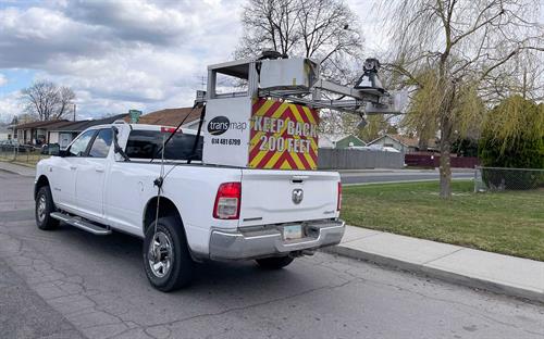
You may have seen a truck drive down your neighborhood street with technical equipment mounted on the back. The City now contracts with Transmap to gather the information using a combination of video cameras and lasers and digitizing that information. One of these high-tech vehicles can travel the streets of Spokane to gather information in less than two weeks. Benefits of this model include reducing risk for streets crew members and having consistent information gathered by the same source at one time provides more accurate information when prioritizing and making decisions.
Transmap collects data on the amount of various defects in the pavement and quantifies it for each segment. This is an automated process using cameras and lasers. The pavement information gathered from the assessment is fed into our Pavement Management System (PMS), StreetSaver, where a score is calculated from this data. Streetsaver also keeps track of historic maintenance and rehabilitation projects, along with segment specifications such as length, width, thickness, etc.
The City conducts these inspections on a rotating basis, every two years for arterials and every four years for local access or residential streets.
Source: City of Spokane